
smilequi9653
27.07.2021 •
History
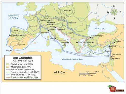
The map below shows the Crusades from 1095 A.D. (CE) through 1204 A.D. (CE). Use the map to answer the following question:
Map of the First through Fourth Crusades, 1095 CE - 1204 CE. The map shows Europe and North Africa bordering the Mediterranean Sea. Islamic areas are shaded brown; Christian areas are shaded green. Europe, with the exception of Spain is shaded green. Africa, much of the Middle East, and the southern half of Spain are shaded brown. Lines of different colors mark the routes of the four Crusades. The first and second Crusades follow land routes from northern and central France through Italy, and also from Germany through southeastern Europe along the Danube River. The third crusade follows a sea path from England around Spain to southern France, and from central France to southern France, and then to the Holy Land.
© 2012 The Exploration Company
Which of the following likely contributed to the path of the third Crusade?
Much of North Africa was held by Muslims; therefore, Crusaders approached from the east.
Much of Europe was held by the Christians; therefore, Crusaders traveled straight through the Mediterranean.
Much of Spain was held by Muslims; therefore, Crusaders traveled around it by sea rather than through it.
Much of Italy was held by Muslims; therefore, Crusaders hugged the border of Croatia and Serbia.
Solved
Show answers
More tips
- S Science and Technology How to Choose a Picture Frame: Tips and Recommendations...
- F Family and Home Choosing the Right Car Seat for Your Child: Tips and Recommendations...
- F Food and Cooking How to Get Reconfirmation of Registration?...
- C Computers and Internet How to Get Rid of Spam in ICQ?...
- A Art and Culture Who Said The Less We Love a Woman, the More She Likes Us ?...
- F Family and Home How to Get Rid of Your Neighbors?...
- S Society and Politics How Could Nobody Know About the Dead Mountaineers?...
- H Health and Medicine How to Cure Adenoids?...
- H Health and Medicine Why Wearing a Back Brace Can Be Beneficial During Back Strain?...
- S Sport When and Where Will the 2014 World Cup be Held?...
Answers on questions: History
- C Chemistry What is the oxidation number of N2...
- H History Explain the importance of a fire during the neolithic age...
- B Biology Why dose the amount of water in a river change during the year...
- M Mathematics Pls help me i will really help me...
- C Chemistry The phosphate salt of the antiviral drug Tamiflu contains 5 elements (C, H, O, N, and P). If the mass percent of Tamiflu is 47.17% C, 6.877 % N, 31.42% 0, and 7.603% P, what...
Ответ:
I think its growing rates of urbanization as migrants predominantly settled in cities in the receiving societies.
Explanation: from the internet